| Forest Management Unit |
Ontario Ministry of Natural Resources |
2006 |
|
| Forest Misc. Damage Event |
Ontario Ministry of Natural Resources |
2008 |

|
| Forest Processing Facility |
Ontario Ministry of Natural Resources |
1998 - 2008 |

|
| Forest Resource Inventory (FRI), Digital Aerial Imagery |
Ontario Ministry of Natural Resources |
2006 - 2018 |

|
| Forest Resource Inventory (FRI), Wetland |
Ontario Ministry of Natural Resources |
2012 |
|
| Forest Resources Inventory (FIM v2 3D) Packaged Product |
Ontario Ministry of Natural Resources |
2007 |
|
| Forest Resources Inventory Status (FRI-Status) |
Ontario Ministry of Natural Resources |
2011 |
|
| Forest Resources Planning Composite Inventory (FRI-PCI) |
Ontario Ministry of Natural Resources |
2004 - 2011 |
|
| Forts Region |
DMTI Spatial Inc. |
2015 - 2023 |

|
| Forward Sortation Area Boundaries (FSA) |
DMTI Spatial Inc. |
2001 - 2014 |

|
| Forward Sortation Areas Region (FSA) |
DMTI Spatial Inc. |
2015 - 2023 |

|
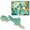
| France and Belgium [Roggel]. 1:25,000. Map Sheet 36 (North), Going Map, [1944] |
Great Britain. War Office. General Staff. Geographical Section. |
1944 |
|
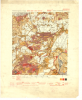
| Garderen, Holland. 1:25,000. Map Sheet 371 (East), 2nd Edition, Defence Overprint, 22 March 1945 |
United States. Army Map Service |
1945 |
|
| Gas and Oil Facilities Point |
DMTI Spatial Inc. |
2015 - 2023 |

|
| Gas and Oil Facilities Region |
DMTI Spatial Inc. |
2015 - 2023 |

|
| Gas and Oil Field Point |
DMTI Spatial Inc. |
2015 - 2023 |

|
| Gas Stations Point |
DMTI Spatial Inc. |
2015 - 2023 |

|
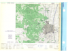
| Geldern, Eastern Holland. 1:25,000. Map Sheet 4403, 2nd Edition, Defence Overprint, 18 December 1944 |
United States. Army Map Service |
1944 |

|
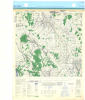
| Geldern, Eastern Holland. 1:25,000. Map Sheet 4403, 3rd Edition, Defence Overprint, 18 February 1945 |
United States. Army Map Service |
1945 |
|
| Geldern, Eastern Holland. 1:25,000. Map Sheet 4403, 3rd Edition, Defence Overprint, 6 February 1945 |
United States. Army Map Service |
1945 |
|