Revision Note: Please note that this dataset has been revised and is available from the Land Information Ontario (LIO) Warehouse.
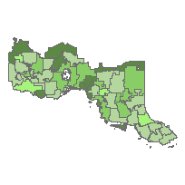
This layer provides the general current production status of all Forest Resources Inventory (FRI) units in the province of Ontario. It also indicates the availability of digital inventories (Planning Composite (Initial), Base Model Inventory (BMI), and Planning Composite (final)) from the Land Information Ontario Warehouse (LIOW), Ontario Ministry of Natural Resources (OMNR) as structured (Forest Cover data class) and packaged (zip file) products.
The Forest Resource Inventory (FRI) is an extensive survey of the forest resources of Ontario. It was originally designed in 1946 to locate merchantable timber species for supplying mills.
The FRI was designed as a large-scale survey that would allow general characterization of the forest in terms of species, forest conditions and regeneration. Traditionally, the FRI has been based on aerial photo interpretation, as well as some field surveys.
A Forest Management Unit (FMU) is a designated administrative area that depicts a forest management boundary. The area within these boundaries are used for forest resource planning and management purposes of the Crown Forest Sustainability Act. An FMU is primarily identified by an assigned official name and a unique numeric code.
Forest inventories are differentiated by the following two versions or products:
1) Forest Resources Inventory (FRI): This is the initial or first new data capture version of the forest resource inventory for a unit that is delivered to OMNR Districts and Sustainable Forest Licence (SFL) holders. In most cases, it involves the complete re-inventory of the forested land within a unit. It provides a basis for planning inventories described below.
2) Planning Composite Inventory (PCI): Once delivered, the FRI (1) is updated by OMNR Districts and Forest Companies for Forest Management Planning purposes. Spatial and attribute data are updated on an as-required or scheduled basis to reflect changes to the forest landscape (e.g. natural disturbances, harvesting and regeneration). The planning inventory contains additional attributes and information that conform to Forest Information Manual (FIM) standards to support the forest management planning process.
Access this resource on Scholars Geoportal.
Access this resource on Scholars Geoportal.