Resources
Permitted Use of the Maps: McMaster University Library is providing digital access to these maps and charts and the ability to download high resoultion copies (600 dpi, 1GB, .TIF) for non-commercial purposes only. For allowable use of the images found on this website, see the Creative Commons License.
Historical Maps and Views
19th century survey plans for the City of Hamilton are available in digital format from the LRMC. Paper originals are available in the Library Archives and Research Collections.
A 1791 Survey Map of Hamilton by Augustus Jones is available in paper format only in the LRMC.
An 1840 Bird's-Eye View of Hamilton is available in paper and digital format from the LRMC.
An 1851 Map of Hamilton by Marcus Smith is available in paper format only in the LRMC.
An 1851 Map of the Town of Dundas by Marcus Smith is available in paper and digital format from the LRMC.
An 1854 Bird's-Eye View of the City of Hamilton, Canada West, by Edwin Whitefield is available in paper and digital format from the LRMC.
An 1859 Map of Wentworth County by Robert Surtees is available in paper format only in the LRMC.
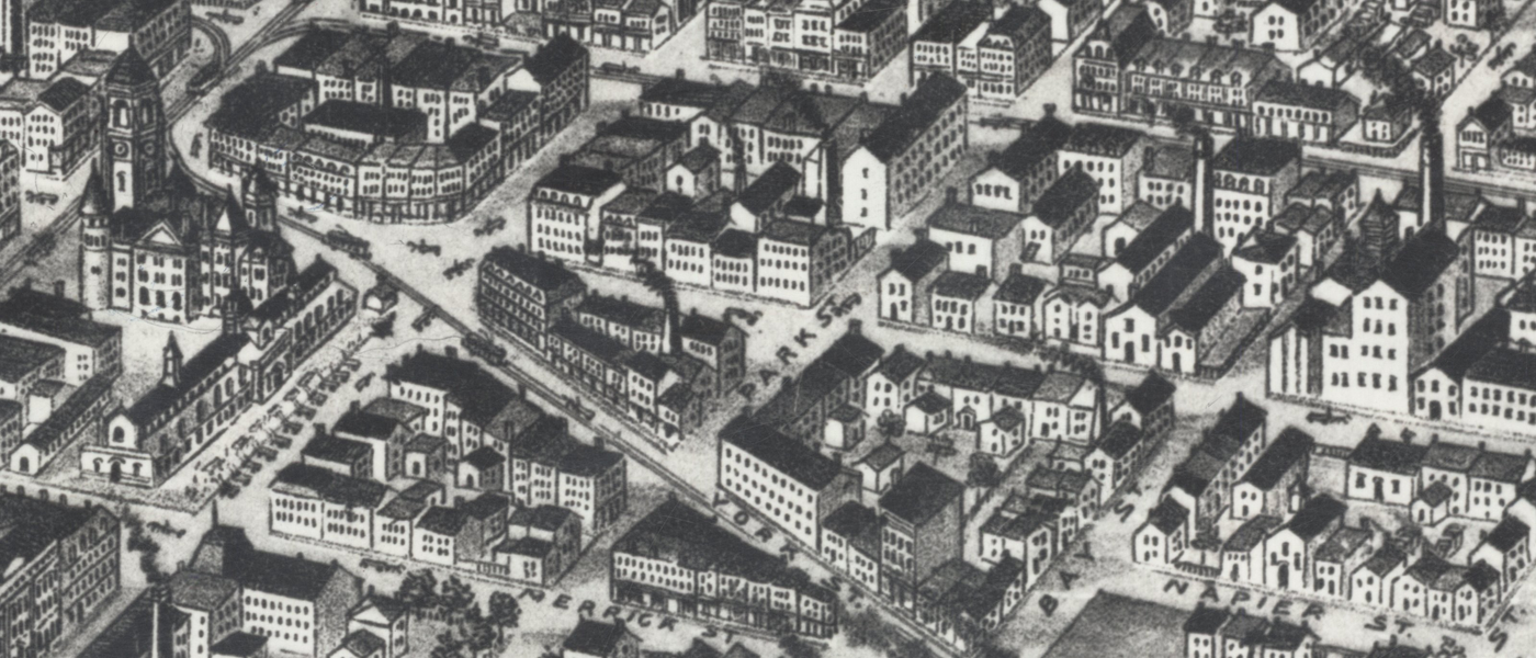
An 1859 Bird's-Eye View of Hamilton, County of Wentworth, is available in digital format from the U.S. Library of Congress website.
An 1859 map of Wentworth County can be found on the Ontario Historical County Maps Project website, hosted by the University of Toronto. The project is a collaboration between several Ontario universities to digitize all the Ontario county maps from the 1800s.
Views of the City of Hamilton in 1860 during the visit of the Prince of Wales is available in paper and digital format from the LRMC.
An 1871 View of the City of Hamilton from a photograph by R. Milne is availabe in paper and digital format from the LRMC.
The 1875 Wentworth County Atlas (which includes the City of Hamilton) is available in paper format in the LRMC but is also available (excluding some of the text) in digital format from McGill University on their Canadian County Atlas Digital Project website.
An 1876 Bird's-Eye View of Hamilton is available in paper and digital format from the LRMC.
An 1880 View of Hamilton by the Belden Bros. is available in paper and digital format from the LRMC.
An 1891 Abrey and Tyrrell's Map of the City of Hamilton is available in paper format only in the William Ready Division of Archives and Research Collections, Mills Library, lower level, accession number 107450.
An 1893 Bird's-Eye View of Hamilton is available in paper and digtial format from the LRMC.
Surveyors' Notebooks
These are microfilmed copies of the original field notebooks of the British surveyors, commissioned by the crown to layout new townships and roads in Upper Canada, at the turn of the 18th and 19th centuries. In addition to survey calculations and sketch maps, the field notebooks contain such information as soil type, availability and type of timber, general climate, the location of natural harbours, rivers and bays, and the general suitability for settlement. For those involved in restoration biology, these fieldbooks are probably the only detailed record of what the landscape looked like before it was cleared for settlement.
Available in microfilm format in the LRMC only. If you are planning a visit to view these notebooks, please allow a large amount of time as the books can be complex to navigate, and the 18th century cursive handwriting can be difficult to interpret.
Fire Insurance Plans
All Canadian Fire Insurance Plans in our collection published 90 years or more ago, have been digitized and made accessible from our website. We have sets for Hamilton for the years 1898, 1911, 1947 (an incomplete set), and 1964. The "key" to the colours and symbols used on the plans as well as our recommended guide to citing the plans can also be found on our website. Copyright restrictions require that plans less than 90 years old must only be viewed in paper, hard-copy format in the Lloyd Reeds Map Collection (LRMC).
Aerial Photographs
Aerial photo coverage for the local Hamilton area dates from 1919 to the present. Aerial photo coverage can be browsed by location and year using the Library's Historical Hamilton Portal. Copyright restrictions require that photos less than 50 years old are to be viewed and used within the Lloyd Reeds Map Collection only. Photos older than 50 years are out-of-copyright and have been digitized and made accessible via the Portal, along with a recommended citiation guide.
1927 Aerial Photo Mosaic Map of the City of Hamilton by Jack V. Elliot Air Service, Ltd. and W. L. McFaul, City Engineer. Available in paper and digital format from the LRMC.
City Directories
The LRMC has a complete set of annual volumes of city directories for the City of Hamilton for the years 1853 to 2013 (when the Vernon Publishing Company ceased production).
1853-1969: available in microfilm format in the LRMC but also available in digital format from the Internet Archive and Hamilton Public Library.
1970-1997: available in microfilm fomat only at the Lloyd Reeds Map Collection.
1998-2013: available in paper format only at the Lloyd Reeds Map Collection.