Great Ice sheets have covered parts of Ontario several times, most recently during the Quaternary Period. This most recent glaciation has played a major role in shaping and creating the physical landscape of Ontario. The deposits and effects of these glaciations are widespread with till being the most common deposit left by the Laurentide Ice Sheet. Three main end members of till were produced, sandy tills from the erosion of Precambrian rocks; silty tills derived from the erosion of carbonate rocks and clayey tills deposited in front of the glacier in local or regional area of ponding. Considerable volumes of melt water were generated by, and discharged from, the glaciers that once occupied Ontario. Large amounts of glacial debris were transported by the meltwater and deposited as stratified sediments under the glacier and along the ice margin (glaciofluvial ice-contact deposits), and beyond the ice margin in rivers and streams (glaciofluvial outwash deposits), lakes (glaciolacustrine and lucustrine deposits) and seas (glaciomarine and marine deposits).
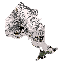
The Quaternary Geology Data Set is a digital interpretation of this Surficial Geology for the Province of Ontario, illustrating the general distribution of the various types of Quaternary sediments and the major landforms associated with them. Glacial tills, fluvial, lacustrine and organic deposits are illustrated as 30 distinct structured geological units illustrating the Quaternary stratigraphy of Ontario. Also shown are landform deposits such as drumlins, moraines, eskers, sand dunes, and glacial related escarpments.
Access this resource on Scholars Geoportal.
Access this resource on Scholars Geoportal.