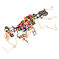
The OC Transpo Route Digitization Project was started in May 2014 with the goal of digitizing OC Transpo transit routes since 1929. The project was undertaken by Carleton University’s Maps, Data, and Government Information Centre (MADGIC) with funding provided by a Young Canada Works summer internship grant.
For 1929-2016, ArcMap 10.2 was used to process open data files provided by the cities of Ottawa and Gatineau, with scanned transit maps from OC Transpo used as reference. After 2016, (vector - polyline) feature layers with individual transit routes were compiled at Carleton's MacOdrum Library from static GTFS files provided by the City of Ottawa.
Each feature layer includes all individual transit routes operated by OC Transpo that year, and it contains information for:
- Route Number
- Route Type (Regular, Peak, Express, Rural, etc.)
- Mode of Transportation (bus, train)
- Year
More details about the project and data processing can be found under Data Quality and Additional Documentation.
Access this resource on Scholars Geoportal.
Access this resource on Scholars Geoportal.
