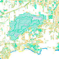
The Natural Heritage Areas Inventory of Niagara and Haldimand County is a project that was conducted between April 2006 and December 2009 for the purpose of identifying, classifying and mapping natural heritage areas in the Niagara region watershed (NPCA’s jurisdiction). The goal of the project was to use industry standard, scientifically-defensible protocols to inventory all of the natural areas in the community. The resulting data and map provides a representation of the natural cover and features of the Niagara watershed using the Ecological Land Classification (ELC), a standard in Ontario to classify natural areas.
Those who have spent time in the natural areas in and around Niagara know that this part of the province, with its Carolinian heritage and proximity to the Great Lakes, is a treasure trove of natural wonders. These areas support a rich diversity of natural features including rare plants and animals, significant habitats and geological formations, and important wildlife corridors. A comprehensive biological inventory to document the vegetative communities of our watershed and their inhabitants has never been completed. As data was collected, the project built on existing information ultimately confirming the significance of known sites and filling information gaps. The result is a solid resource of information, which includes accurate natural heritage mapping, a list of local rarity, and site specific species information that will be of tremendous benefit to all watershed residents.The data collected through the project has helped to foster the development of greater environmental awareness within the community, prioritize restoration opportunities and, will serve as baseline for planning decisions and policy development.
Access this resource on Scholars Geoportal.
Access this resource on Scholars Geoportal.
