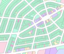
This data was provided by The City of Hamilton, Dept. of Planning and Economic Development, GIS - Planning and Analysis.
This dataset delineates all land parcels in the City of Hamilton, and provides the street address, as well as the type of land use for each parcel. Land use is generally classified as: Residential, Institutional, Office, Commercial, Warehousing/Wholesale/Storage, Industrial, Utilities/Transportation, Parks/Open Space, Agriculture, Vacant Lands/Parking, and Miscellaneous.
Within each of these classes, the parcels are more specifically classified, as described below:
- Residential - subdivided into detached house, semi-detached house, row/townhouse, apartment, mobile Home etc.
- Institutional - subdivided into pre-school, elementary/secondary school, post secondary institution, place of worship, galleries, emergency and military services, government, hospital, Rooming House, Correctional Services etc.
- Commercial - subdivided into general retail, recreation and sports clubs, restaurant, auto sales and repairs, auto service station, accomodations etc.
- Industrial - subdivided into light, medium, and heavy industry, as well as mines/quarries/gravel pits.
- Utilities - subdivided into heat/hydro/energy station, waste water, landfill, and transmission.
- Transportation - subdivided into railway yards, public depots, port facilities and airports.
- Parks/Open Space - subdivided into outdoor amusement/exhibition grounds, open space, golf course, burial facilities etc.
- Vacant Lots - subdivided by redisential, institutional, industrial etc.
- Parking - subdivided by private and municipal.
