Retirement note: The data from this packaged product has been superseded by the LIO layers: Natural Heritage System Area and Greenbelt River Valley Connections, and is available from the Land Information Ontario (LIO) Warehouse.
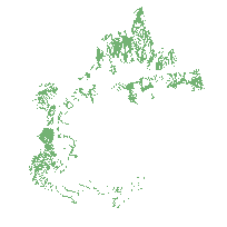
The Natural Heritage System identifies areas of the Greenbelt Protected Countryside with the highest concentration of the most sensitive and/or significant natural features and functions as outlined in section 3.2 and schedule 4 of the Greenbelt Plan, February 28th 2005.
The Greenbelt Act, 2005 enables the creation of a Greenbelt Plan to protect about 1.8 million acres of environmentally sensitive and agricultural land in the Golden Horseshoe from urban development and sprawl. The Protected Countryside contains a Natural System that provides a continuous and permanent land base necessary to support human and ecological health in the Greenbelt and beyond.
Also included in this data product (side note: added as a seperate service in the Scholars GeoPortal) is the External Connections (source water - rivers) layer which identifies the river valley connections referenced in section 3.2.5 of the Greenbelt Plan. These connections identify linkages beyond the Greenbelt Natural Heritage system through existing or approved urban areas to inland lakes and Lake Ontario.
Access this resource on Scholars Geoportal.
Access this resource on Scholars Geoportal.