This series provides data sets that can be used to identify bedrock units, dike swarms, faults, granulite facies, iron formations, and kimberlite and lamprophyre in Ontario.
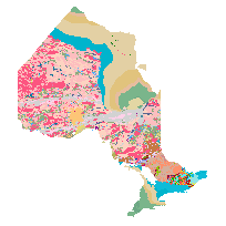
This data set is part of the Bedrock Geology Data Set, which is a Geological map of the Province and shows the distribution of bedrock units underlying Ontario. It illustrates geological rock types, major faults, iron formations, kimberlite intrusions, and dike swarms. The geology of the Province consists of Precambrian rocks of the Canadian Shield and Phanerozoic sedimentary rocks in basins that overlie the Canadian Shield. Based on differences in age, metamorphism and tectonic setting, the Precambrian rocks are subdivided into the Superior, Southern and Grenville provinces. The Phanerozoic rocks occur in four basins. Major faults and shear zones are also included. The legend is subdivided geochronologically in the Phanerozoic, but geochronometrically in the Proterozoic and Archean. The Archean rocks of the Superior Province are subdivided into lithologic units. Supracrustal units of the Southern Province and the Phanerozoic Eon are subdivided lithostratigraphically. The Grenville Province is subdivided into major tectonic blocks and within each block the legend is mainly lithologic, with only part of the supracrustal rock record subdivided into lithostratigraphic units. The dataset is an overview of this geology on a Provincial Compilation scale of 1:250 000 and it illustrates geological rock types, major faults, iron formations, kimberlite and dike swarms.
Access this resource on Scholars Geoportal.
Access this resource on Scholars Geoportal.
