Description
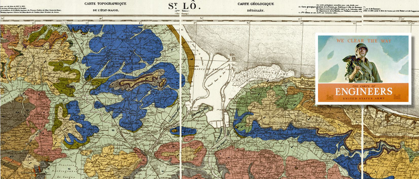
Geology played as important a role as topography in the selection of the invasion area for ‘Operation Overlord.’ The two geologic map sheets from this series—St. Lo (sheet 28) and Caen (sheet 29)—cover the D-Day beach head and are wartime reproductions of 19th century French originals made by the British for use in the planning of D-Day.
Although the Pas de Calais was the shortest distance across the English Channel, not only was it more heavily defended, but the cliffs were more numerous along that stretch of coastline than in Normandy. Normandy also had a minimum of clay and depressions which was better suited for the landing of troops and supplies. It was also in proximity to the port of Cherbourg which would be a high value objective for the Allies in order to resupply the invasion.
After the failure at Dieppe, the Allies learned the lesson that a heavily fortified port could not be taken from the sea but only by land. However, the Contentin peninsula had at one time been an island after the last ice age, and the southern portion is largely reclaimed marsh with a complex drainage system. Road exits from the western most landing beach, Utah, were located in this area and were flooded by the Germans, turning the roads into causeways for as much as 3 km. It would take some time for U.S. troops to make their way up the peninsula to Cherbourg, only to discover a sabotaged port facility after capturing the town.
The Allies had anticipated this and had made alternate plans for supply through rapidly constructed, temporary airfields. At least a dozen would be needed initially, and by the end of August, 23 were in place. This was one of the main reasons for the selection of Normandy. The Calvados plateau between Bayeux and Caen stands on a foundation of oolitic limestone of ‘Bradfordian’ (Mid Jurassic) age, depicted in yellow on the map, with slightly older Caen limestone indicated in pink. This limestone base was ideal for the siting of airfields, as well as providing good, well-drained sites for the location of supply dumps. Materials for road repair and construction such as sands, gravels, and road metals (stone chips for use in tarmac) were also close at hand.
One disadvantage of the local geology was that the limestone was covered in some areas by superficial deposits of Pleistocene loess which has a proclivity for breaking into a yellow, powdery dust when dried out and subject to stresses. This gave away the positions of moving vehicles to the enemy and had a tendency to foul engines. Limestone can also be cavernous and therefore has the potential to transmit and amplify sound. This has led to the famous anecdote of a German officer who supposedly placed his ear to the ground and was able to hear British tanks massing miles away for an attack on Caen.
References and Recommended Reading:
Clough, A. B. (1952). The Second World War 1939-1945, Army Maps and Survey. London: War Office.
Doyle, P. and Matthew, B. (2002). Fields of Battle: Terrain in Military History. London: Kluwer Academic.
Rose, E.P.F., et al (2006) Specialist Maps Prepared by British Military Geologists for the D-Day Landings and Operations in Normandy, 1944. The Cartographic Journal, v.43 (2), pp. 117-145.