WWI Tsetse Fly Map of German East Africa
View the Map
The map is actually entitled, "Communications Between German Bridge and Central Railway."
References:
Farwell, Byron. The Great War in Africa, 1914-1918. Harmondsworth: Viking, 1987.
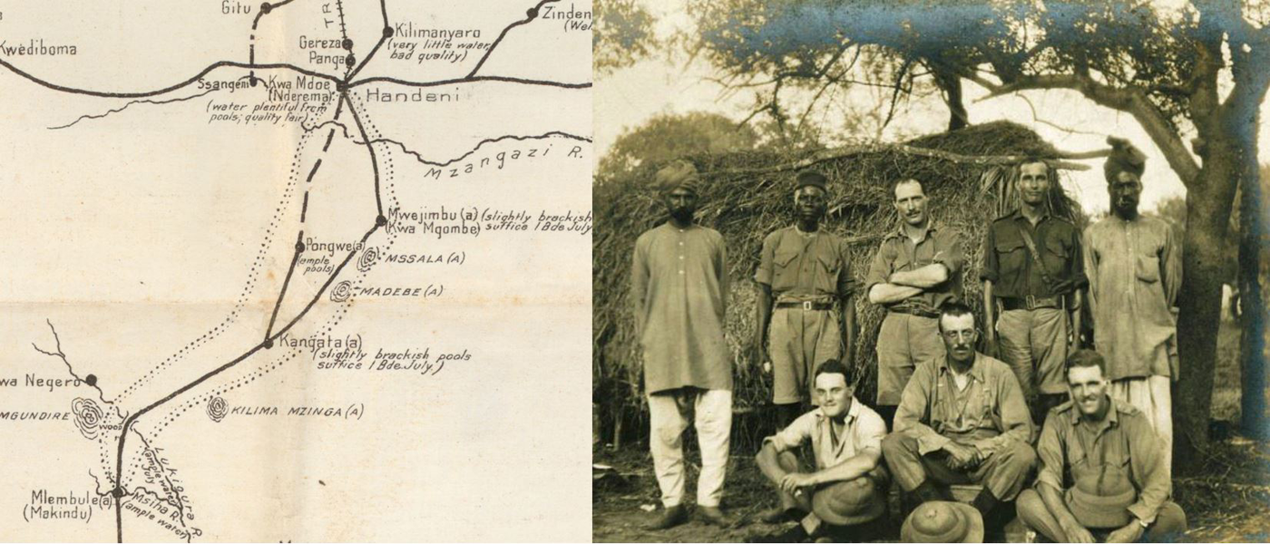
This very rare map in McMaster's WWI Map Collection entitled, Communications Between German Bridge and Central Railway--but affectionately referred to as the "Bug" map--was produced by the British Army in July of 1916, and was most likely copied from an earlier German version. It shows the main road, bridge, and railway network through German East Africa (now Tanzania, Rwanda and Burundi), just south of British East Africa (now Kenya). It appears at first to be a fairly skeletal, even boring bit of cartography, however, closer inspection reveals the unique and deadly perils of the African Campaign that were equal to the machine gun or poison gas of the Western Front.
Colonel Josiah Wedgewood, a descendant of the founder of the famous Wedgewood pottery firm, is claimed to have said that the fighting in the region called, Tsavo (made famous by the Val Kilmer and Michael Douglas film Ghosts and the Darkness) was "like fighting in a zoo." Over a span of 18 months, the British lost 30 men to lions and rhinos. Soldiers on both sides feared more the enemy with four legs or six, than any of the two-legged variety. Running out of good water to drink was more of a danger than running into the enemy. This map in McMaster's collection bears witness to that fact. Although the map appears to be quite minimal in detail, you will notice the large amount of attention that is given to the location and quality of each source of water.
By 1916, the ratio of non-battle casualties caused by diseases (such as typhoid and enteric fever) to battle casualties, was more than 30 to 1. Soldiers too thirsty to wait for water to be filtered were likely to swallow infected water fleas, resulting in cases of parasitic guinea worm. Chiggers or "Jiggers" as the British called them, burrowed into a soldier's feet, while the ever-present mosquito injected him with malaria. On several occasions battles were interrupted and came to a full stop when swarms of angry bees attacked both armies.
The domain of the most feared six-legged enemy of all, however, can be seen clearly marked on the "Bug" map. The borders of the kingdom of the Tsetse fly are delineated with a double-dotted line, creating a dominion of dread from Makindu in the south to Handeni in the north. Byron Farwell, in his book The Great War in Africa, states "the Germans had maps indicating the fly areas and the British were said to have seen these but little use appears to have been made of them." This map, in McMaster's collection, would seem to prove his point. In an interesting side note, the German forces in East Africa were the very last troops in the Great War to lay down their arms. Their protracted refusal to surrender was due to the delay in receiving the news of the Armistice from Europe.
Read the related news article by Erica Balch.
McMaster University is committed to providing websites that are accessible to the widest possible audience.
If you require any content on this website in an alternative format, please complete the Report an Accessibility Issue form and we will respond as promptly as possible.