Trenches Corrected to Date
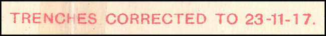
The scanned image below is taken from the top margin of a trench map and warns the reader of the currency of information depicted .
When we think of WWI we usually think of two, long, static lines of opposing trenches. Although the front line trenches may not have moved very frequently, new support and communication trenches were always being constructed. Also, newly discovered information about the enemy like the positions of machine guns, trench mortars and army units meant trench maps could become outdated very quickly. For these reasons a system was developed later in the war that could update trench maps on a weekly or, if necessary, a daily basis.
The Ordnance Survey in England printed numerous copies of each topographic map to be used as base maps. Tactical Information subject to change, like trench locations and enemy defenses, could then be printed on top of these base maps by a survey and printing unit near the front. The updated maps could then be quickly distributed to front line officers. In this way, only corrections to the overlay printing would have to be made. This saved the effort of reproducing the entire map each time you wished to make small but significant changes.
The scanned image below is taken from the top margin of a trench map and warns the reader of the currency of information depicted .
McMaster University is committed to providing websites that are accessible to the widest possible audience.
If you require any content on this website in an alternative format, please complete the Report an Accessibility Issue form and we will respond as promptly as possible.