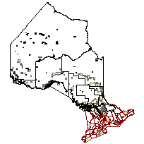
This data set can be used to identify upper tier municipalities, single tier municipalities, and districts.
Upper tier municipalities are two or more lower tier municipalities that form for municipal purposes. Municipal responsibilities have been set out under the Municipal Act and other Provincial legislation are split between the upper tier and lower tier municipalities.
Single tier municipalities are municipalities that do not form part of an upper tier municipality for municipal purposes and assumes all responsibilities set out under the Municipal Act and other Provincial legislation.
Districts (or territorial districts) are geographic areas in northern Ontario, which are described in the Territorial Division Act, and are composed of municipalities, geographic townships, and unsurveyed territory. This layer is part of what was known as the OMNR Fundamental Dataset.
Access this resource on Scholars Geoportal.
Access this resource on Scholars Geoportal.