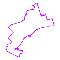
Polygon of the GTHA (Greater Toronto and Hamilton Area) boundary. Created from the Ontario Ministry of Natural Resources 2012 Municipal Boundary shapefiles:
- Municipal Boundary – Upper Tier and District
- Municipal Boundary – Lower and Single Tier
Includes the following single & lower tier municipalities: City of Brampton, City of Burlington, City of Mississauga, City of Oshawa, City of Pickering, City of Toronto, City of Vaughan, Municipality of Clarington, Town of Ajax, Town of Aurora, Town of Caledon, Town of East Gwillimbury, Town of Georgina, Town of Halton Hills, Town of Markham, Town of Milton, Town of Newmarket, Town of Oakville, Town of Richmond Hill, Town of Whitby, Town of Whitchurch-Stouffville, Township of Brock, Township of King, Township of Scugog, Township of Uxbridge. Also includes the following upper tier municipalities: Regional Municipality of York, Regional Municipality of Peel, Regional Municipality of Durham, Regional Municipality of York, City of Hamilton.
Access this resource on Scholars Geoportal.
Access this resource on Scholars Geoportal.
