Year
2009
Abstract
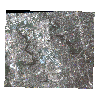
This dataset consists of an georeferenced GeoEye (IKONOS-2) satellite image taken on September 1, 2009. The image is of the central part of North York (Toronto) including York University Keele Campus, Yonge Street, Downsview Park, and surroundings.
The image mosaic service consists of two image files in GeoTIFF format: A a 11bit panchromatic (black and white) image with a 1 metre resolution and multispectral image with a 4 metre resolution. The multispectral image contains the following four bands:
- Band 1 = Blue
- Band 2 = Green
- Band 3 = Red
- Band 4 = Near-infrared
Additional product metadata and HDR files containing raster parameters are available in the additional documentation section below
URL
Access this resource on Scholars Geoportal.
SGP_id
3028756580
Scholars Geoportal URL
Access this resource on Scholars Geoportal.