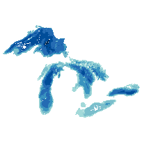
This data set contains bathymetry of the Great Lakes in metres (depth).
The Great Lakes Bathymetry Contours data set has been compiled as a component of a NOAA project to rescue Great Lakes lake floor geological and geophysical data and make it more accessible to the public. This bathymetry of the Great Lakes including Lake Ontario, Lake Erie, Lake Saint Clair, Lake Huron, Lake Michigan, Lake Superior provides a detailed look at the lake floor topography and serves as a GIS base layer for many applications.
This project is a cooperative effort between investigators at the NOAA National Geophysical Data Center's Marine Geology and Geophysics Division (NGDC/MGG), the NOAA Great Lakes Environmental Research Laboratory (GLERL) and the Canadian Hydrographic Service (CHS). Bathymetric data have been collected from the Great Lakes in support of nautical charting for at least 150 years by the US Army Corp. of Engineers (before 1970), the NOAA National Ocean Service (NOS) (after 1970), and the Canadian Hydrographic Service.
Access this resource on Scholars Geoportal.
Access this resource on Scholars Geoportal.