WWII 
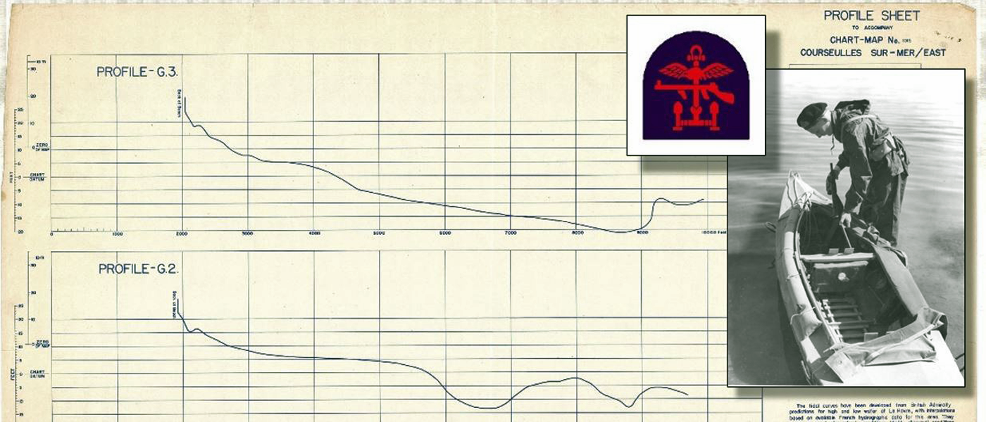
Beach Gradient Profiles

Beach gradient profiles played a large part in determining just where and when the Allied amphibious assault troops would be landed on D-Day. If the gradient was too shallow, or the tide too low, the landing craft would be grounded far from the shore, leaving the disembarking troops with too great a distance to traverse under enemy fire. Alternately, if the invasion were to take place at high tide in an effort to land the troops closer to the beach wall, there was a risk of the landing craft becoming snagged or punctured from underneath by beach obstacles such as 'hedgehogs' and 'Belgian gates,' or blown-up by mines attached to the ends of wooden poles driven into the English Channel floor. In order to make a complete assessment of the situation, all potential landing areas were photographed from the air at six different stages of the tide. A  photo mosaic map was then constructed from all the low tide photos and the intermediate water lines (all six stages) were superimposed on the map.

Aerial photographs were also taken in order to map all natural and man-made obstacles. Some photos were taken at oblique angles, while some verticals were taken as low as thirty to fifty feet from the ground. The reconnaissance pilots who flew these missions referred to them as "dicey" because they were rolling dice with death. These low-level photos were also valuable because they could reveal dark patches of peat after a storm had moved the lighter-coloured covering sand. Peat was a potential obstacle to cross-beach mobility, so extensive testing was undertaken with a large number of varied vehicles under different tide conditions on similar beaches back behind friendly lines in the UK, such as the beach at Brancaster in Norfolk. The "dicing" photos also revealed the depth of wheel marks left by German carts transporting devensive stores, and this information was used to assess the load-bearing properties of the beach. Experts in the physics of sand movement and the action of marine waves on the formation and erosion of beaches were also appointed to the task.

Hydrographic surveys were surreptitiously undertaken at night in small boats under the noses of German sentries, in order to gather information that would be used for the installation of the Mulberry harbours, as well as for the landings themselves. Midget submarines were used to deploy amphibious scouts who swam ashore at night to covertly gather sediment and stone samples, as well as to examine obstacles, beach exits, and measure the height of the cliffs at the back of the beach. French labourers paced out the distance between obstacles and fed the information to the resisitance. Businessmen and engineers travelling to Britain from the continent were pumped for information. Even pre-war postcards were used to gather information about the beaches.

In the end, the Allies were convinced that the landing craft would have to come in at low tide and discharge the troops before reaching the zone of beach obstacles.

References:

Allen, Gordon. (2005). Mapping and Charting for the Greatest Collaborative Project Ever. The American Surveyor. June.

Allen, T. (2002). Untold Stories of D-Day. National Geographic, v.201 (6), pp. 2-37.

Chasseaud, P. (2001). Mapping for D-Day: The Allied Landings in Normandy, 6 June 1944. The Cartographic Journal, v.38 (2), pp. 177-189.

Rose, E.P.F., et al (2006) Specialist Maps Prepared by British Military Geologists for the D-Day Landings and Operations in Normandy, 1944. The Cartographic Journal, v.43 (2), pp. 117-145.