Year
1944
Abstract
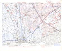
This is a 1:25,000 scale map (defence overprint) of the region of Zeebrugge, France and Belgium. It was published on October 3, 1944 by the Geographical Section, General Staff (GSGS) of the War Office of Great Britain.
This overprint utilizes the Nord de Guerre Zone Grid.
Production information for the overprint is 3050/10/44/3RCE/5217.
URL
Access this resource on Scholars Geoportal.
SGP_id
WWIIMMZeebruggeSW_03101944_TIFF
Scholars Geoportal URL
Access this resource on Scholars Geoportal.
