Year
1944
Abstract
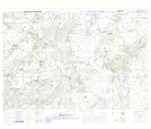
This is a 1:25,000 scale map of Potigny, France, prepared for the purpose of Operation Totalize (August 8-9, 1944). It is a defence overprint published by the Geographical Section, General Staff (GSGS) of the War Office of Great Britain on August 6, 1944. This overprint was referenced from air photographs taken August 1, 1944, counter-battery sources taken August 3, 1944, and ground sources taken August 5, 1944.
Production information for the overprint is 2010/8/44/3RCE/5028.
URL
Access this resource on Scholars Geoportal.
SGP_id
WWIIMMPotigny_1944_TIFF
Scholars Geoportal URL
Access this resource on Scholars Geoportal.