Year
1945
Abstract
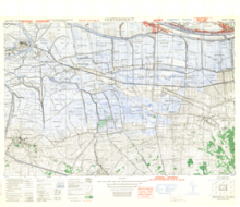
This is a 1:25,000 scale map (defence overprint) of the region of Oosterhout, Holland. It is an emergency printing of this map, published on January 20, 1945 by the Army Map Service of the United States Armed Forces.
This overprint was referenced from air photographs taken January 16 1945, and utilizes the Nord de Guerre Zone Grid (Blue).
Production information for the base map is 3M/11/44/3RE/5371. Production information for the overprint is 270/1/45/3RCE/5575.
URL
Access this resource on Scholars Geoportal.
SGP_id
WWIIMMOosterhout_1945_TIFF
Scholars Geoportal URL
Access this resource on Scholars Geoportal.