Year
1944
Abstract
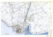
This is a 1:10,000 scale map (defence overprint) of the regions of Koudekerke-Vlissingen and Oostsouburg, Holland. It is the first edition of this map, published on October 28, 1944 by the Royal Canadian Engineers.
This overprint was referenced from air photographs taken October 24, 1944 and ground information taken October 21, 1944, and it utilizes the Nord de Guerre Zone Grid (Blue).
URL
Access this resource on Scholars Geoportal.
SGP_id
WWIIMMKoudekerkeVlissingenOostsouburg_1944_TIFF
Scholars Geoportal URL
Access this resource on Scholars Geoportal.