Year
1944
Abstract
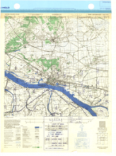
This is a 1:25,000 scale map (defence overprint) of the region of Emmerich, Eastern Holland. It is the third edition of this map, published in December 1944 by the Army Map Service of the United States Armed Forces. The defence overprint was traced by the Royal Canadian Engineers.
This overprint utilizes the Nord de Guerre Zone Grid (Blue).
Production information for the map is 22/DEC/44/16MRS/811/773. Production information for the overprint is 210/1/45/3RCE/5547.
URL
Access this resource on Scholars Geoportal.
SGP_id
WWIIMMEmmerich_1944_TIFF
Scholars Geoportal URL
Access this resource on Scholars Geoportal.