Year
1944
Abstract
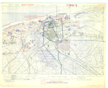
This is a 1:25,000 scale composite map (defence overprint) of Calais, France, published on September 12, 1944. It is a composite of several sheets (38 NE, 39 NW, 28 SW) published by the Geographical Section, General Staff (GSGS) of the War Office of Great Britain.
Production information for the overprint is 2010/9/44/3RCE/5170.
URL
Access this resource on Scholars Geoportal.
SGP_id
WWIIMMCalais_1944_TIFF
Scholars Geoportal URL
Access this resource on Scholars Geoportal.
