Decoding a WWI Aerial Photo Number
The First line
indicates the series and the photo number.
An "O" was included preceding the photo number if the photo was taken at an "oblique" angle rather than the normal vertical angle. Scale remains constant over the entire photo in vertical angle shots but varies from one side of a photo to the other in oblique angle shots.
The Second line
indicates the day, month, year and time of day when the picture was taken.
The Third line
lists map reference numbers that correspond to the area covered by the photograph (see: How to Read a WWI Map Reference Number).
A letter and number combination (e.g. F=8 or F-8) can be found on the second line following the date information or occasionally on a separate, fourth line as in the example below. It indicates the focal length of the camera in inches and can be used to determine the scale of a photo if the altitude is known.
Note: The symbol that looks like a white cross to the left of the numbers in the closeup is actually a North arrow.
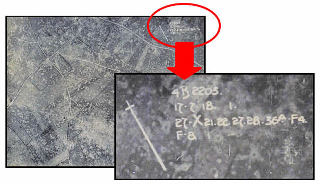
Here is an example taken from the photo above:
4B2205.
17.7.18-1.
27.X21.22.27.28.36a.F4
F-8.
Line 1: 4B2205.
This line is a combination of the series number & photo number:
4B (series number) 2205 (photo number).
Line 2: 17.7.18-1.
17. (day), 7. (month), 1918. (year) -1 p.m. (time of day).
Line 3: 27.X21.22.27.28.36a.F4.
27. (map sheet number)
X21.22.27.28. (squares X21, 22, 27 & 28 on map sheet 27)
36a. (map sheet number)
F4. (square F4 on map sheet 36a)
The area covered by this air photo is the equivalent of the area covered by squares X21, X22, X27 and X28 on map sheet 27 and square F4 on map sheet 36a.
Note: the periods should help you determine where the map sheet numbers end and where the numbers for the squares begin. Map sheet numbers can also contain letters (e.g. "36a") as in the example above.
Line 4: F-8
(focal length of camera = 8". this can be used in conjunction with the altitude, if known, to determine the scale of the photo).
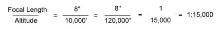
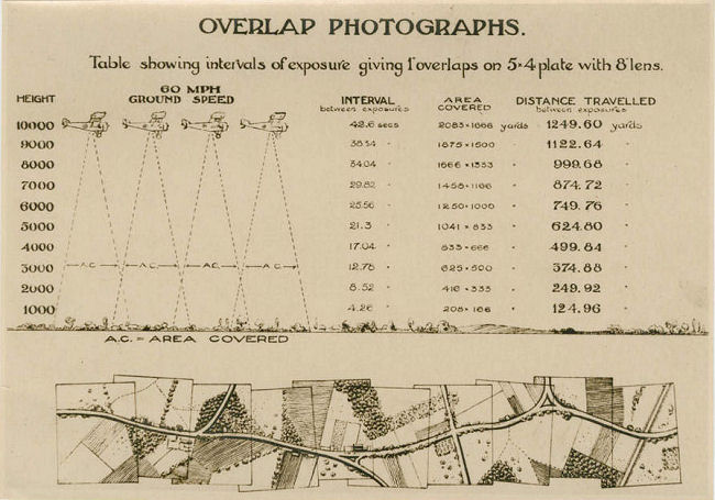
Diagram of Overlapping Photo Technique: