
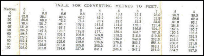
| Conversion Table |
| The 'Conversion Table' is simply a tool for converting metres to feet. |
| This is signifiicant because British artillerymen were accustomed to calculating elevations and distances in Imperial measurements of feet or yards. At the beginning of the war the only British maps available of the area in conflict were of too small a scale to be of any use. The only large scale maps available were of French and Belgian origin and were therefore in metric units, forcing the artillerymen to make conversions. The British experimented with overlaying a grid of 1,000 yard squares on the French and Belgian maps but this caused problems when a gun was located on one map and its target on another as the grid did not align properly with adjoining map sheets. |
| The image below is taken from the bottom margin of a trench map. |
 |
Contact: mapref@mcmaster.ca