
| Corner Coordinates | |
| The state of coordinate and grid systems at the beginning of the war was chaotic to say the least. Many of the only maps available were old and of various national origins. At one time each nation, except England, used its own capital city as the point through which to run the prime meridian or "zero" line of longitude. England chose the site of its Royal Observatory in Greenwich. When examining the maps from this time period one must determine whether or not the degrees are West or East of Paris, Brussels or Greenwich. | |
| The British soon dropped the latitude and longitude system based on degrees in favour of a military grid of 1,000 yard squares to aid its artillery in ranging and to make map referencing easier. This, however, was eventually changed to a grid of 1,000 metre squares in order to properly fit the French and Belgian base maps which were in metric units. | |
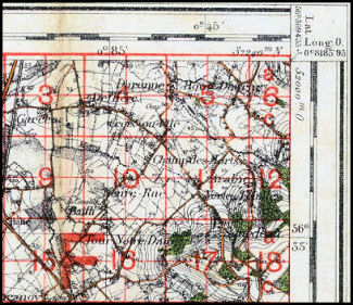
| Latitude & Longitude Coordinate System with Imperial grid of 1,000 yard squares |
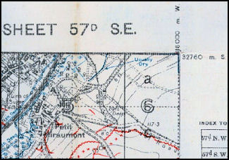
Military Map Reference System with Metric grid of 1,000 metre squares |
 |
 |
| Note: the Imperial grid of 1,000 yard squares (red) extends past the top edge of the base map. This created problems when working with adjacent map sheets as the grids would overlap instead of align. | |
Contact: mapref@mcmaster.ca