| How to Read Map Reference Numbers: |
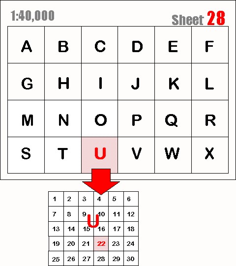
| The diagram below represents the grid on a typical World War I map at a scale of 1:40,000. |
| It is divided into 24 lettered squares labelled A to X. |
| We will use the following map reference number as an example: |
| 28.U.22.C.3.2. |
| The first number in the reference pertains to the map sheet number "28". |
Note:
sheet numbers can also contain letters, as in sheet number "36cNW1" at 1:10,000 scale.
see: scale.
|
Next, follows the first letter which refers to the grid square "U" on that sheet.
Each lettered grid square is then divided into smaller squares numbered from
1 to 30 (in some cases 1 to 36). |
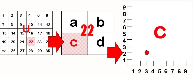
In this example, the square number "22" is indicated in the map reference.
|
 |
This square 22 is then further divided into 4 squares labelled "a", "b", "c" & "d".
In this example we have used the letter "C".
|
Finally, square U.22.C. can be even further divided into tenths.
On a 1:10,000 scale map you will actually see small division lines like those in the diagram below.
|
The first number is read from left to right.
In this example the number is "3" so, our reference point is 3 tenths from the left. |
Our second number is read from the bottom of the square up.
In this example it is
a "2" so, our point is also 2 tenths up from the bottom. |
 |