
| How to Read Aerial Photograph Numbers: | |
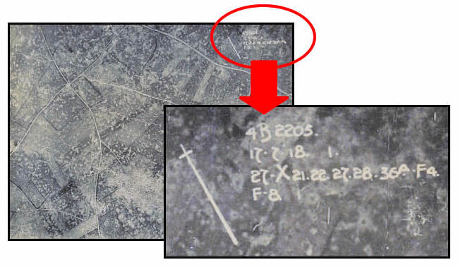
| There can typically be 3 or 4 lines of numbers present on WWI air photos. These numbers usually appear in the upper, right-hand corner of the photo but placement can vary. These lines are normally in the same sequence as listed below but have also been known to vary. |
|
| The First line indicates the film negative series and the photo number. An "O" was included preceding the photo number if the photo was taken at an "oblique" angle rather than the normal vertical angle. Scale remains constant over the entire photo in vertical angle shots but varies from one side of a photo to the other in oblique angle shots. |
|
| The Second line indicates the day, month, year and time of day when the picture was taken. | |
| The Third line lists map reference numbers that correspond to the area covered by the photograph (see: How to Read Map Reference Numbers). | |
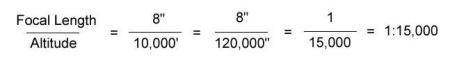
| A letter and number combination (e.g. F=8 or F-8) can be found on the second line following the date information or occasionally on a separate, fourth line as in the example below. It indicates the focal length of the camera in inches and can be used to determine the scale of a photo if the altitude is known. | |
|
|
 |
|
| Here is an example taken from the photo above: | |
4B2205. |
|
17.7.18-1. |
|
27.X21.22.27.28.36a.F4 |
|
F- 8. |
|
| Line 1: 4B2205. | |
| This line is a combination of the film negative series number & photo number: | |
|
|
| Line 2: 17.7.18-1. | |
|
|
| Line 3: 27.X21.22.27.28.36a.F4. | |
|
|
|
|
|
|
|
|
| The area covered by this air photo is the equivalent of the area covered by squares X21, X22, X27 and X28 on map sheet 27 and square F4 on map sheet 36a. | |
|
|
| Line 4: F-8 | |
|
|
 |
|
| German Notation: | |
| The following is an approximate translation of an example of the notation sometimes found on the verso (back) of German aerial photographs: | |
| German | English approximate translation |
| Feld-Flieger Abt.__ | Field-Flight Dept.__ |
| Bild no.__ | Photo No.__ |
| objekt__ | object__ |
| Aufgen. durch__ | Photo taken by__ |
| Vermessungs Abetilung nr.__ der __ Armee | Surveying Department No.__ of the __ Army |
| Briefstempel__ | Letter Stamp__ |
| Kartenstelle Hy__ | Map Dept. Hy__ |
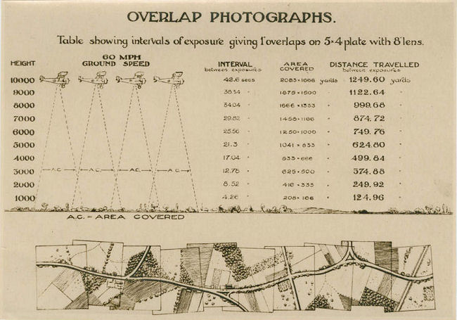
| Diagram of Overlapping Photo Technique: | |
 |
|
Contact: mapref@mcmaster.ca