Credits
The WWII Topographic Map Series Project represents the Lloyd Reeds Map Collection's first 'in-house' digitization project. McMaster University Library wishes to thank the many geography and geology graduates whose generous gifts helped to fund the purchase of a large-format scanner, without which, this project would not have been possible.
|
| The over 3,000 maps in the WWII topo and Special Strategic Map series were electronically captured with a Colortrac SmartLF GX+T56 scanner at 600 dpi optical, 24 bit tonal resolution and saved in .TIF (archival), JPEG (thumbnail) and JPEG2000 (scalable) formats. |
|
The Library also wishes to recognize the important contributions of:
|
Karen Tan, Map Collection Student Assistant
Map preparation, scanning, editing, metadata and revision to procedural documentation for all series except those listed below.
|
Sarah LoConte, Map Collection Student Assistant
Initial testing of equipment, scanning & editing of France 1:250,000 and authoring of procedural documentation.
|
Jenny Ni, Map Collection Student Assistant
Map preparation, scanning, editing and metadata for England & Wales, Scotland, Hong Kong, Borneo and the Strategic Map Series.
|
Gabriela Mircea & Nick Ruest, Digital Repository Librarians |
Margaret Rutten, Digital Access Specialist |
Gord Beck, Map Specialist |
John Maclachlan, Manager, Maps/Data/GIS |
| |
| Image Credit |
|
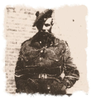 |
Russell "Sandy" Sanderson
Sniper-Scout, Scout Platoon
1st Battalion, the Black Watch
Royal Highland Regiment of Canada.
Holland
February 1945.
Image courtesy of Russell Sanderson Hamilton, Ontario.
Sandy's major duty was reconnaissance.
For this, he relied heavily on maps like those in the Holland 1:25,000 scale series. It was my distinct pleasure to have met and talked with Sandy about his use of these maps in the field.
Gord Beck, Map Specialist
Lloyd Reeds Map Collection |
|
