RESULTS FOR GRID SQUARE 28
MAPS FOR GRID SQUARE 28
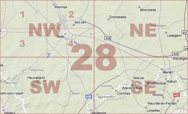
Map Location Diagram
- The Map Location Diagram (right) shows the relative position of places within the area of this grid square.
- Maps having this Map Reference Number will cover the whole area but be less detailed.
- Maps with NE, NW, SE or SW in the Map Reference Number will only cover one-quarter of the whole area but be more detailed.
- Click the following links for more information about How to Read a Map Reference Number or about Map Scale.
Maps for Grid Square 28
| Link to Image | Map Sheet Number | Scale | Area | Date |
|---|---|---|---|---|
|
PC0783WW1MAP |
20, 28, 36 | 1:100,000 | ||
|
PC0219WW1MAP |
27 SE & 28 SW (combined) | 1:20,000 | Godewaerevelde - Strazeele | 1918/05 |
|
248WW1MAP |
27,28 & 36a (parts) | 1:40,000 | Bailleul | 1918/04 |
|
322WW1MAP |
28 | 1:40,000 | Ypres | 1917/02 |
|
371WW1MAP |
28 | 1:40,000 | Ypres | 1917/02 |
|
311WW1MAP |
28 | 1:40,000 | Ypres | 1918/01 |
|
301WW1MAP |
28 NE | 1:20,000 | Dadizeele | 1918/09 |
|
302WW1MAP |
28 NE | 1:20,000 | Dadizeele | 1918/09 |
|
PC0237WW1MAP |
28 NE | 1:20,000 | Gravenstafel - Kruiseecke | 1917/07 |
|
PC0238WW1MAP |
28 NE | 1:20,000 | Gravenstafel - Kruiseecke | 1917/07 |
|
PC0239WW1MAP |
28 NE | 1:20,000 | Gravenstafel - Kruiseecke | 1917/10 |
|
PC0240WW1MAP |
28 NE | 1:20,000 | Gravenstafel - Kuriseecke | 1917/10 |
|
PC0241WW1MAP |
28 NE | 1:20,000 | Gravenstafel - Kruiseecke | 1917/12 |
|
PC0487WW1MAP |
28 NE1 | 1:5,000 | Frezenburg - Anzac | |
|
PC0022WW1MAP |
28 NE1 | 1:10,000 | sGravenstafel - Frezenberg | 1916/00 |
|
PC0023WW1MAP |
28 NE1 | 1:10,000 | sGravenstafel - Frezenberg | 1916/00 |
|
PC0024WW1MAP |
28 NE1 | 1:10,000 | sGravenstafel - Frezenberg | 1916/00 |
|
PC0025WW1MAP |
28 NE1 | 1:10,000 | sGravenstafel - Frezenberg | 1917/07 |
|
PC0026WW1MAP |
28 NE1 | 1:10,000 | sGravenstafel - Frezenberg | 1917/09 |
|
PC0027WW1MAP |
28 NE1 | UNKNOWN | sGravenstafel - Frezenberg | 1917/12 |
|
PC0028WW1MAP |
28 NE2 | 1:10,000 | East of Zonnebeke and Passchendaele | 1917/12 |
|
PC0029WW1MAP |
28 NE3 | 1:10,000 | Westhoek - Kruiseecke | 1917/04 |
|
PC0030WW1MAP |
28 NE3 | 1:10,000 | Westhoek - Kruiseecke | 1917/07 |
|
PC0031WW1MAP |
28 NE4 | 1:10,000 | Dadizeele - Klythoek | 1917/09 |
|
PC0223WW1MAP |
28 NW | 1:20,000 | Poperinghe - Reninghelst | 1914/00 |
|
PC0226WW1MAP |
28 NW | 1:20,000 | Poperinghe - Reninghelst | 1916/00 |
|
PC0858WW1MAP |
28 NW | 1:20,000 | Poperinghe - Reninghelst | 1917/03 |
|
PC0228WW1MAP |
28 NW | 1:20,000 | Poperinghe - Reninghelst | 1917/04 |
|
PC0229WW1MAP |
28 NW | 1:20,000 | Poperinghe - Reninghelst | 1917/04 |
|
PC0230WW1MAP |
28 NW | 1:20,000 | Poperinghe - Reninghelst | 1917/07 |
|
PC0231WW1MAP |
28 NW | 1:20,000 | Poperinghe - Reninghelst | 1917/07 |
|
PC0234WW1MAP |
28 NW | 1:20,000 | Poperinghe - Reninghelst | 1917/07 |
|
PC0235WW1MAP |
28 NW | 1:20,000 | Poperinghe - Reninghelst | 1917/07 |
|
PC0236WW1MAP |
28 NW | 1:20,000 | Poperinghe - Reninghelst | 1917/07 |
|
304WW1MAP |
28 NW | 1:20,000 | Ypres | |
|
PC0232WW1MAP |
28 NW & 28 NE (composite) | 1:20,000 | Poperinghe - Gheluvelt | 1917/07 |
|
PC0233WW1MAP |
28 NW & 28 NE (composite) | 1:20,000 | Poperinghe - Moorsele | 1918/00 |
|
PC0233WW1MAP |
28 NW & 28 NE (composite) | 1:20,000 | Poperinghe - Moorsele | 1918/00 |
|
PC0013WW1MAP |
28 NW1 | 1:10,000 | Poperinghe - Boesinghe | |
|
PC0564WW1MAP |
28 NW2 | 1:10,000 | Boesinge - English Farm | |
|
PC0014WW1MAP |
28 NW2 | 1:10,000 | Boesinghe - Wieltje | 1917/04 |
|
PC0015WW1MAP |
28 NW2 | 1:10,000 | Broesinghe - Wieltje | 1917/07 |
|
PC0489WW1MAP |
28 NW3 | UNKNOWN | Camp South of Reninghelst | |
|
PC0016WW1MAP |
28 NW3 | 1:10,000 | British area west of Ypres | 1918/07 |
|
PC0486WW1MAP |
28 NW4 | 1:5,000 | Oskar Farm - Clapham Junction | |
|
PC0562WW1MAP |
28 NW4 | 1:10,000 | Ypres Town Plan | |
|
PC0563WW1MAP |
28 NW4 | 1:10,000 | Potizje - Shrewsbury Forest | 1915/06 |
|
PC0566WW1MAP |
28 NW4 | 1:10,000 | Potijze - Menin Road | |
|
PC0017WW1MAP |
28 NW4 | 1:10,000 | Goldfish Chateau - Voormezeele | 1916/00 |
|
PC0018WW1MAP |
28 NW4 | 1:10,000 | Goldfish Chateau - Vormezeele | 1917/05 |
|
PC0019WW1MAP |
28 NW4 | 1:10,000 | Goldfish Chateau - Voormezeele | 1918/07 |
|
PC0020WW1MAP |
28 NW4, NE3 | 1:10,000 | Ypres - Trois Rois | 1916/00 |
|
PC0021WW1MAP |
28 NW4, NE3 | 1:10,000 | Ypres - Trois Rois | 1917/04 |
|
PC0250WW1MAP |
28 SE | 1:20,000 | Zandvoorde - Wervicq | 1917/04 |
|
PC0251WW1MAP |
28 SE | 1:20,000 | Zandvoorde - Wervicq | 1918/01 |
|
PC0494WW1MAP |
28 SE1 | 1:5,000 | Wervicq | 1917/02 |
|
PC0049WW1MAP |
28 SE1 | 1:10,000 | Zandvoorde - Lys River | 1917/04 |
|
PC0050WW1MAP |
28 SE1 | 1:10,000 | Zandvoorde - Lys River | 1917/09 |
|
PC0051WW1MAP |
28 SE2 | 1:10,000 | Menin | 1917/08 |
|
PC0052WW1MAP |
28 SE3 | 1:10,000 | East of Messines | 1918/09 |
|
PC0242WW1MAP |
28 SW | 1:20,000 | Westoutre - Bailleul | 1914/00 |
|
PC0243WW1MAP |
28 SW | 1:20,000 | 1914/00 | |
|
PC0244WW1MAP |
28 SW | 1:20,000 | Westoutre - Bailleul | 1915/00 |
|
PC0244WW1MAP |
28 SW | 1:20,000 | Westoutre - Bailleul | 1917/04 |
|
PC0247WW1MAP |
28 SW | 1:20,000 | Westoutre - Bailleul | 1917/04 |
|
PC0248WW1MAP |
28 SW | 1:20,000 | Westoutre - Bailleul | 1918/05 |
|
PC0249WW1MAP |
28 SW | 1:20,000 | Westoutre - Bailleul | 1918/08 |
|
PC0252WW1MAP |
28 SW & SE (parts of) | 1:20,000 | Vierstraat - Messines | 1917/08 |
|
PC0253WW1MAP |
28 SW & SE (parts of) | 1:20,000 | Vierstraat - Messines | 1917/11 |
|
PC0032WW1MAP |
28 SW1 | 1:10,000 | Westoutre - Wolfhoek | 1915/00 |
|
PC0033WW1MAP |
28 SW1 | 1:10,000 | Westoutre - Wolfhoek | 1916/12 |
|
PC0034WW1MAP |
28 SW2 | 1:10,000 | Wytschaete | 1915/00 |
|
PC0035WW1MAP |
28 SW2 | 1:10,000 | Vierstraat - Garde-Dieu | 1916/00 |
|
PC0036WW1MAP |
28 SW2 | 1:10,000 | Vierstraat - Garde-Dieu | 1916/00 |
|
PC0037WW1MAP |
28 SW2 | 1:10,000 | Vierstraat - Garde-Dieu | 1917/01 |
|
PC0041WW1MAP |
28 SW2 | 1:10,000 | Vierstraat - Garde-Dieu | 1917/04 |
|
PC0042WW1MAP |
28 SW2 | 1:10,000 | Vierstraat - Garde-Dieu | 07/1917 |
|
PC0042WW1MAP |
28 SW2 | 1:10,000 | Vierstraat - Garde-Dieu | 07/1917 |
|
PC0038WW1MAP |
28 SW2 | 1:10,000 | Vierstraat - Garde-Dieu | 1917/04 |
|
PC0039WW1MAP |
28 SW2 | 1:10,000 | Vierstraat - Garde-Dieu | 1917/04 |
|
PC0040WW1MAP |
28 SW2 & SW4 | 1:10,000 | Hollandscheschuur farm - Warneton | 1917/04 |
|
PC0502WW1MAP |
28 SW3 | 1:5,000 | Bailleul Village and Area | |
|
PC0043WW1MAP |
28 SW3 | 1:10,000 | S of Kemmel and W of Ploegsteert | 1918/08 |
|
PC0046WW1MAP |
28 SW4 | 1:10,000 | Ploegsteert | 1916/00 |
|
PC0046WW1MAP |
28 SW4 | 1:10,000 | Ploegsteert | 1916/00 |
|
PC0569WW1MAP |
28 SW4 | 1:10,000 | La Polka Cabaret - Messines | 1915/00 |
|
PC0044WW1MAP |
28 SW4 | 1:10,000 | Ploegsteert | 1915/00 |
|
PC0045WW1MAP |
28 SW4 | 1:10,000 | Ploegsteert | 1916/00 |
|
PC0047WW1MAP |
28 SW4 | 1:10,000 | Wulverghem - Pont Rouge | 1917/04 |
|
PC0048WW1MAP |
28 SW4 | 1:10,000 | Wulverghem - Pont Rouge | 1917/07 |
|
PC0565WW1MAP |
Part of Sheet 28 | 1:10,000 | Krupp Farm - Westhoek | 1915/00 |
|
PC0490WW1MAP |
Part of Sheet 28 | 1:5,000 | Verbrandenmolen - Battle Wood | 1917/05 |
|
PC0491WW1MAP |
Part of Sheet 28 | 1:5,000 | Hazelbury & Lankoff Farms - The Stables | 1917/05 |
|
PC0492WW1MAP |
Part of Sheet 28 | 1:5,000 | Wytschaetebeek - Mahieu Fm | 1917/05 |
|
PC0493WW1MAP |
Part of Sheet 28 | 1:5,000 | Peckham - Betlheem Fm | 1917/05 |
|
PC0568WW1MAP |
Part of Sheet 28 | 1:10,000 | Rossignol Wood - Wulverghem | 1916/00 |
|
PC0570WW1MAP |
Part of Sheet 28 | 1:10,000 | A la 1/2 Lune Cacaret - Messines | 0000/00 |
|
PC0584WW1MAP |
Part of Sheet 28 | 1:10,000 | Tiendenberg - Eddy Fm. | 1917/12 |
|
PC0585WW1MAP |
Part of Sheet 28 | 1:10,000 | Poelcappelle - Assyria | 1918/01 |
|
PC0587WW1MAP |
Part of Sheet 28 | 1:10,000 | Zillebeke Lake - America Cabt. | 1917/12 |
|
PC0588WW1MAP |
Part of Sheet 28 | UNKNOWN | Ypres-Roulers Railway - Polygon Wood | 1917/09 |
|
PC0589WW1MAP |
Part of Sheet 28 | UNKNOWN | Westhoek - Polygon Wood | 1917/09 |
|
PC0590WW1MAP |
Part of Sheet 28 | UNKNOWN | Polygon Wood - Gheluvelt | 1917/09 |
|
PC0591WW1MAP |
Part of Sheet 28 | 1:10,000 | Boesinghe - No Mans Cot | 1917/04 |
|
PC0592WW1MAP |
Part of Sheet 28 | 1:10,000 | Zillebeke - Klein Zillebeke | 1917/04 |
|
PC0593WW1MAP |
Part of Sheet 28 | 1:10,000 | Verbrandenmolen - Hollebeke | 1917/04 |
|
PC0594WW1MAP |
Part of Sheet 28 | 1:10,000 | Bois Carre - Oostaverne | 1917/04 |
|
PC0595WW1MAP |
Part of Sheet 28 | 1:10,000 | St. Eloi - Bug Wood | 1917/05 |
|
PC0596WW1MAP |
Part of Sheet 28 | 1:10,000 | Vierstraat - Huns Fm | 1917/04 |
|
PC0597WW1MAP |
Part of Sheet 28 | 1:10,000 | Byron Farm - Green Wood | 1917/04 |
|
PC0598WW1MAP |
Part of Sheet 28 | 1:10,000 | Ouderdom - Wulverghem | |
|
PC0600WW1MAP |
Part of Sheet 28 | 1:10,000 | Suvla Wood - Ravelsberg Camp | 1918/08 |
|
PC0601WW1MAP |
Part of Sheet 28 | 1:10,000 | E end of Hill 63 - R. Lys | 1914/12 |
|
PC0645WW1MAP |
Part of Sheet 28 | 1:20,000 | ||
|
PC0646WW1MAP |
Part of Sheet 28 | 1:20,000 | ||
|
PC0647WW1MAP |
Part of Sheet 28 | 1:20,000 | Canal - Winnipeg | |
|
PC0648WW1MAP |
Part of Sheet 28 | 1:20,000 | St. Eloi - Kasteelhoek | 1917/05 |
|
PC0654WW1MAP |
Part of Sheet 28 | UNKNOWN | Ypres - Klein Zillebeke | |
|
PC0730WW1MAP |
Part of Sheet 28 | 1:40,000 | Ypres Salient | 1917/12 |
|
PC0731WW1MAP |
Part of Sheet 28 | 1:40,000 | Ypres Salient | 1917/12 |
|
PC0757WW1MAP |
Part of Sheet 28 | 1:100,000 | Somme battlefield | 1916/07 |
|
PC0797WW1MAP |
Part of Sheet 28 | 1:100,000 | 1918/04 | |
|
PC0798WW1MAP |
Part of Sheet 28 | 1:100,000 | 1918/04 | |
|
PC0653WW1MAP |
Part of Sheet 28 | 1:20,000 | Potijze - Terhand | |
|
PC0719WW1MAP |
Part of Sheet 28 | 1:20,000 | Wieltje - Polygon Wood | 1917/06 |
|
PC0720WW1MAP |
Part of Sheet 28 | 1:20,000 | Poelcappelle - Moorslede | 1917/06 |
|
PC0722WW1MAP |
Part of Sheet 28 | 1:20,000 | Pilckem Ridge - Gheluvelt | 1917/06 |
|
PC0567WW1MAP |
Part of Sheet 28 | 1:10,000 | Verbrandenmolen - Kortwilde | 1915/00 |
|
PC0573WW1MAP |
Part of Sheet 28 | 1:10,000 | Mondovi Farm - Rat House | |
|
PC0583WW1MAP |
Part of Sheet 28 | 1:10,000 | Poelcappelle - area NW of Passchendaele | 1917/10 |
|
PC0586WW1MAP |
Part of Sheet 28 | 1:10,000 | Verbrandenmolen - Nebley Fm | 1917/11 |
|
PC0789WW1MAP |
Part of Sheet 28 and 36 | 1:100,000 | Bergues - Lille | 1917/10 |
|
PC0577WW1MAP |
Part of sheet 28 | 1:10,000 | Alouette Fm - Kansas Cross | 1917/09 |
|
PC0579WW1MAP |
Part of sheet 28 | 1:10,000 | St. Julien - Sans Souci | 1917/08 |
|
PC0580WW1MAP |
Part of sheet 28 | 1:10,000 | St. Julien - Y Wood | 1917/07 |
|
PC0581WW1MAP |
Part of sheet 28 | UNKNOWN | St. Julien - Y Wood | 1917/07 |
|
PC0582WW1MAP |
Part of sheet 28 | 1:10,000 | Keir Fm - North & South Station Buildings | 1917/08 |
|
PC0547WW1MAP |
Part of sheet 28 | 1:10,000 | Houthulst Forest - Kortekeer Cabaret | 1917/12 |
|
PC0576WW1MAP |
Part of sheet 28 | 1:10,000 | Namur Crossing - Wolf Copse | 1917/09 |
|
PC0736WW1MAP |
Parts of 27,28, 36, 36a | 1:40,000 | Hazewinde - Doulieu | 1918/07 |
|
PC0792WW1MAP |
Parts of Sheets 28 and 36 | 1:100,000 | Ypres - Bethune | 1918/04 |
|
PC0800WW1MAP |
Parts of Sheets 28 and 36 | 1:100,000 | Coast at Bray Dunes - Estaires | 1918/05 |
|
PC0801WW1MAP |
Parts of Sheets 28 and 36 | 1:100,000 | Coast Dunkerque to Bray Dunes - Estaires | 1918/06 |
|
PC0802WW1MAP |
Parts of Sheets 28 and 36 | 1:100,000 | Coast Dunkerque to Bray Dunes - Estaires | 1918/06 |
|
PC0803WW1MAP |
Parts of Sheets 28 and 36 | 1:100,000 | Coast Dunkerque to Bray Dunes - Estaires | 1918/06 |
|
PC0799WW1MAP |
Parts of Sheets 28, 29, 36 | 1:100,000 | St Omer - Armentieres | 1918/01 |
|
PC0737WW1MAP |
Parts of sheets 27, 28 | 1:40,000 | Bixschoote - Locre |
AERIAL PHOTOGRAPHS FOR GRID SQUARE 28
Aerial Photograph Location Diagram
- Consult the lettered grid (below) in conjuction with the place names on the map location diagram (lower right) to determine which lettered squares cover your area of interest.
- Choose aerial photos in the table below which have those letters directly following the grid square number.
- Click the following link for more information on How to Read an Aerial Photograph Number.
Map Location Diagram

Aerial Photographs for Grid Square 28
| Link to Image | Map Reference Number | Area | Year | Month | Day |
|---|---|---|---|---|---|
|
162WW1AIR |
28.C.29d.I.5b. | Rupprecht farm. | 1917 | 5 | 1 |
|
503WW1AIR |
28.D.13.c. | Passchendaele | 1917 | 9 | 3 |
|
439WW1AIR |
28.D.27. | Ypres Salient. | 1918 | 9 | 16 |
|
499WW1AIR |
28.D.3.4.9.10.11.a.c.15.16.17. | Lens Front. | 1917 | 7 | 22 |
|
198WW1AIR |
28.I.13a. | Ypres. | 1917 | 1 | 29 |
|
200WW1AIR |
28.I.13b. | Ypres. | 1917 | 4 | 24 |
|
199WW1AIR |
28.I.14a. | Ypres. | 1917 | 1 | 29 |
|
182WW1AIR |
28.I.29.35a.b. | Zillebeke; Battlewood; Hill 60. | 1916 | 4 | 1 |
|
181WW1AIR |
28.I.34c.d.O.4a.b. | Canal D'Ypres; Hollebeke; The Bluff. | 1916 | 2 | 20 |
|
154WW1AIR |
28.I.36d. | Klein Zillebeke | 1917 | 8 | 7 |
|
024WW1AIR |
28.I.8a.c. | Ypres Cloth Hall and Menin Gate. | 1916 | 9 | 17 |
|
150WW1AIR |
28.J.10. | Polgone De Zonnebeke | 1917 | 6 | 12 |
|
239WW1AIR |
28.J.14. | 1917 | 9 | 16 | |
|
241WW1AIR |
28.J.14d.15c. | 1917 | 9 | 11 | |
|
192WW1AIR |
28.J.20d. | Tower hamlets; Lewis house. | 1917 | 10 | 17 |
|
193WW1AIR |
28.J.20d. | Tower hamlets; Lewis house. | 1917 | 10 | 17 |
|
194WW1AIR |
28.J.28a. | Gheluvet.; Lewis house; Duplex farm. | 1917 | 10 | 17 |
|
195WW1AIR |
28.J.35b. | Gheluvet; Oude-Kruiseecke. | 1917 | 10 | 17 |
|
242WW1AIR |
28.K.14. | 1917 | 9 | 16 | |
|
376WW1AIR |
28.K.24c | Dibsland farm; Somerby farm. | 1918 | 10 | 1 |
|
377WW1AIR |
28.K.24c. | Dibsland farm; Somerby farm. | 1918 | 10 | 1 |
|
378WW1AIR |
28.K.29b.30c.36b. | 1918 | 10 | 1 | |
|
379WW1AIR |
28.K.30a.b. | 1918 | 10 | 1 | |
|
380WW1AIR |
28.K.30a.b.c. | Menin. | 1918 | 10 | 1 |
|
375WW1AIR |
28.L.19b.20c. | Roulers; Menin. | 1918 | 10 | 1 |
|
374WW1AIR |
28.L.19d. | Menin; Madcap farm; Goldfish farm; Capstan farm; Park drive; Park mill. | 1918 | 10 | 1 |
|
373WW1AIR |
28.L.19d. | Kezelberg; Menin. | 1918 | 10 | 1 |
|
443WW1AIR |
28.L.2b.3c. | Ledeghem | 1918 | 10 | 1 |
|
441WW1AIR |
28.L.2c.d.3c. | Ledeghem, Zonnebeke. | 1918 | 10 | 7 |
|
442WW1AIR |
28.L.2d. | Ledeghem, Rollinghemcappelle. | 1918 | 10 | 7 |
|
388WW1AIR |
28.M.21a.d. | Mont Rouge; Mont Vidagne. | 1918 | 7 | 15 |
|
385WW1AIR |
28.M.28. | 1918 | 7 | 31 | |
|
387WW1AIR |
28.M.3. | 1918 | 7 | 20 | |
|
383WW1AIR |
28.M.35. | 1918 | 7 | 31 | |
|
384WW1AIR |
28.M.35.36. | Dauoutre. | 1918 | 7 | 22 |
|
381WW1AIR |
28.M.8.14. | 1918 | 7 | 17 | |
|
175WW1AIR |
28.N.12-24.O.7-20. | Wytschaete | 1917 | 6 | 3 |
|
235WW1AIR |
28.N.12d.18b. | Wytschaete. | 1917 | 4 | 23 |
|
196WW1AIR |
28.N.18d. | Wytschaete; Byron farm. | 1917 | 5 | 1 |
|
164WW1AIR |
28.N.30-31.O.26-33. | Wytschaete. | 1917 | 6 | 3 |
|
304WW1AIR |
28.N.30. | Ypres canal; Comines canal; La Bassee canal. | 1916 | 8 | 25 |
|
153WW1AIR |
28.N.30.36.O.26. | Wytshaete | 1917 | 6 | 3 |
|
382WW1AIR |
28.N.32c.d.T.2. | 1918 | 7 | 9 | |
|
158WW1AIR |
28.O. | St. Eloi. | 1916 | 4 | 16 |
|
157WW1AIR |
28.O. | St. Eloi. | 1916 | 3 | 31 |
|
197WW1AIR |
28.O.11.12. | Hollebeke. | 1917 | 8 | 9 |
|
245WW1AIR |
28.O.19.20. | Wytschaete. | 1917 | 6 | 12 |
|
191WW1AIR |
28.O.19.20.25.26. | Wervicq. | 1917 | 6 | 2 |
|
152WW1AIR |
28.O.23.24. | Pellegrems farm; Rifle farm. | 1917 | 8 | 9 |
|
205WW1AIR |
28.O.2c.8a. | St. Eloi. | 1917 | 4 | 23 |
|
233WW1AIR |
28.O.32a.V.2a. | Messines. | 1917 | 5 | 1 |
|
168WW1AIR |
28.O.32c.d.U.2. | Messines. | 1917 | 6 | 5 |
|
173WW1AIR |
28.O.32d.V.1b. | Messines. | 1917 | 6 | 2 |
|
167WW1AIR |
28.O.4. | Hollebeke; Canal D'Ypres; White Chau. | 1917 | 5 | 20 |
|
160WW1AIR |
28.O.6c | Hollebeke. | 1917 | 8 | 7 |
|
169WW1AIR |
28.R.8.14. | Menin. | 1917 | 5 | 10 |
|
234WW1AIR |
28.U.22. | Ploegseert wood. | 1917 | 5 | 23 |
|
174WW1AIR |
28.U.3a. | Messines. | 1917 | 6 | 2 |
Contact: mapref@mcmaster.ca