Year
1944
Abstract
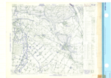
This is a 1:25,000 scale map (defence overprint) of the region of Calcar, Germany. It is the second edition of this map, published on December 16, 1944 by by the Geographical Section, General Staff (GSGS) of the War Office of Great Britain.
This overprint was referenced from air photographs taken December 14, 1944, and utilizes the Nord de Guerre Zone Grid.
Production information for the overprint is 2M/12/44/3RCE/5481.
URL
Access this resource on Scholars Geoportal.
Scholars Geoportal URL
Access this resource on Scholars Geoportal.